Walks
|
Maiden Erlegh Local Nature Reserve 
This walk starts by the Interpretation Centre on Instow Road, but being circular the walk could just as easily be started from Lakeside, Beech Lane, Mawbry Close or via the Green Lane from Gypsy Lane. The walk should take about an hour, depending how much time you take to stop and enjoy the sights.
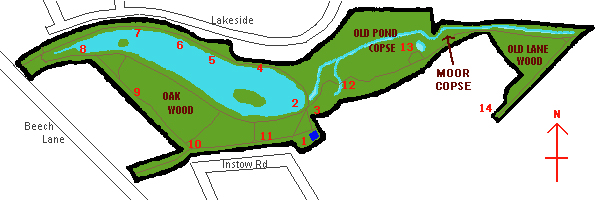
1. Starting at the barrier at the eastern end of Instow Road you pass the Wildlife Garden and Interpretation Centre on your right
- There are over a million acres of private gardens in Britain! Earley Town Council has constructed this wildlife demonstration garden to encourage people to garden in a wildlife friendly manner. Simply by putting in a small (fish-free) pond, feeding the birds and planting a buddleia we can all do our bit!
- The new Environmental Interpretation Centre, which was partly paid for from a grant from Entrust, not only stores all of the equipment needed to manage the reserve but also provides a classroom and workshop that is used by local schools and the "Watch" group.
2. Turn left and follow the path downhill towards the weir. As you pass the end of the lake the duck feeding platform and waterbird identification board is on your left
- One of the most popular activities with visitors to the reserve is feeding the ducks and other waterfowl that live on the lake. In order to make this a safe experience and to enable visitors to get closer to the birds, we have constructed this feeding platform.
- To enhance your visit, Thames Water have kindly sponsored an interpretation board that enables you to identify the birds that make the lake their home.
3. And the wetland area is on your right
- This area was once part of the lake. It became cut off when the present dam/embankment was constructed. We have used the fact that it stays boggy for much of the year to create an area of wet grass for the ducks, geese and swans to feed in.
- As well as benefiting the birds, the area is also a haven for wild flowers such as purple loostrife, yellow flag, marsh marigold and meadow sweet; and animals such as frogs, toads, newts and damselflies.
4. Proceed over the weir bridge and as you walk along the northern bank you will pass a number of Pollarded willows
- If a young, broad-leaved tree is cut across about 2-3 meters from the ground, it will send out fresh shoots and form a bushy crown. This practice, called pollarding, from the Norman-French word poll, meaning head, was once widespread. As the young shoots started growth well clear of the ground, they were safe from grazing cattle and deer.
- Repeated pollarding gave successive crops of small poles suitable for fencing, basketry or firewood. Most of the pollards within the reserve are willows.
5. There are some great views over the lake from here
- The origins of the lake are a mystery. It was created by damming up Maiden Erlegh stream and maps of 1756 show it already in existence. The lake is about 2.4 hectares (6 acres) in area and up to 2 meters (7 feet) deep.
- The majority of the water enters from a series of open and culverted streams that drain central-western Earley. As the water exits the lake at the weir it forms Maiden Erlegh stream whose waters enter the North Sea via the River Loddon and River Thames.
6. And the two islands
- Whilst Solly Joel did not create the actual lake as many people believe, the two islands within the lake can probably be attributed to him, along with the thatched summer house which stood on the North side of the larger island until the late 1960's.
- Today the islands are mainly used by the birds. The small island (Swan Island) is used by the swans, geese and coots, whilst the larger island (Boat Island) is used by the ducks and the great crested grebes.
7. Continuing along the footpath you will see an example of a dead hedge
- You will notice that all of the woodland areas contain a large amount of dead wood - both standing and fallen. This is a vitally important part of a woodland habitat as many of the small woodland creatures spend at least part of their life munching through dead wood or hiding under damp logs. Many people see this dead wood as untidy but in fact a healthy woodland should consist of between 50-70% dead wood!
- Dead wood is also used on this reserve to produce dead hedges. These are used to encourage visitors to stay on the paths and thereby avoid trampling the delicate woodland flowers.
8. Having reached the inlet at the end of the lake bear left and walk back along the southern shore of the lake. It is here that place barley straw in the lake to control the algae
- Due to pollution from agriculture and private gardens, especially nitrates, many lakes suffer from algal blooms. These not only look unsightly but can also be harmful to fish and other animals.
- In order to maintain a high water quality in the lake, twice a year the Rangers and Water Bailiffs use a Christmas tree stuffing machine to produce large barley straw sausages which are then thrown into the lake where they sink. The barley straw works by releasing chemicals into the water as it rots which inhibits the development of algae.
9. After a short distance turn right and walk up Oakwood Meadow
- Since 1945, 98% of flower-rich grassland has been lost in Berkshire due mainly to intensive farming (ploughing up, draining, application of fertilisers and overseeding with ryegrass). In order to provide a valuable habitat for wildlife and to show younger generations how beautiful the British countryside used to be, Earley Town Council has transformed this piece of land from a dull, lifeless monoculture of ryegrass into a beautiful wildflower meadow full of beautiful flowers and butterflies.
10. To the butterfly garden on Instow Road
- This butterfly garden was constructed to:
Provide visitors with an area where they have a good chance of seeing wild animals
Provide the reserve's butterflies and bees with a nectar source
Show people how to attract butterflies to their own gardens
Demonstrate the close relationship between plants & animals
- Because this demonstration area contains at least one of the caterpillar food plants of ALL of the butterflies that live in the British Isles, we think that this garden may be a world first!
11. Turn left and walk past the scallops in the woodland edge to arrive back where you started.
- Due to the combination of light and shelter at the edge of a wood, especially the southern edge, this provides a very valuable habitat. Along Instow Road and down the meadow you can see we have cut semi-circular bites, or scallop, out of the woodland edge. This provides sheltered areas that generate the warm micro-climate needed by many of our insects and other invertebrates, which in turn provide food for animals higher up the food chain such as birds and bats.
12. Walk back down to the weir bridge but this time turn right immediately before the bridge to follow the woodland path. Continue on down a set of steps, over a small bridge, through the Coppice area
- When trees such as hazel, ash and sweet chestnut are cut off just above ground level they produce a crop of long pliable poles that have long been used for bean poles, thatching spars, fire kindling and weaving into hurdle fencing and wattle used in constructing the old black and white Tudor buildings.
- Cutting the stooks back every 7-20 years allows in light that benefits woodland flowers such as bluebells, primroses and wood anemones.
- The word coppice (or copse) comes from the Norman-French word couper, meaning to cut.
13. Continue past the woodland pond on you left, to the end of the boardwalk
- This woodland pond is the last remaining remnant of a second lake that used to occupy much of Old Pond Copse. This lake was also man-made and was created by the construction of the earth embankment that you can see just to the east of the pond.
- This pond is the main breeding site for the frogs that live on the reserve. The fact that the pond dries out in dry years means that it contains few predators such as fish that would eat the tadpoles.
14. Here turn sharp right and follow the woodland path to the Gemini Oak where the path opens out onto the mown grass of Laurel Park.
- These oaks are the oldest trees on the reserve, probably being over 300 years old. If you look carefully at the two trees you will see that the branch of one of them has grafted itself onto the other tree - it's Siamese Twin - hence it's name, the Gemini Oak.
- Experts have debated for many years as to whether the two trunks are from one tree that has split, or from two trees growing close together. Currently the second option is the most favoured theory with one of the trees being slightly younger than the other. What do you think?
15. Walk diagonally right across this field to the gap in the hedge, then past the large lime tree and the children's play area before following the path past the Interpretation Centre to bring you back to your starting point. |
Maiden Erlegh LNR
|